Sale on canvas prints! Use code ABCXYZ at checkout for a special discount!


by Weston Westmoreland
$40.00
Color

Image Size
Product Details
Our youth t-shirts are made from 100% pre-shrunk cotton and are available in five different sizes. All youth t-shirts are machine washable.
Design Details
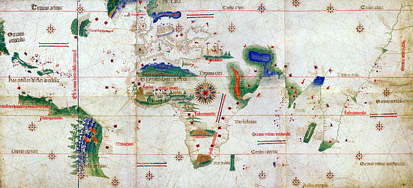
The Cantino Planisphere, 1501 AD.... more
Ships Within
1 - 2 business days

Photograph

Canvas Print

Framed Print

Art Print

Poster

Metal Print

Acrylic Print

Wood Print

Greeting Card

iPhone Case

Throw Pillow

Duvet Cover

Shower Curtain

Tote Bag

Round Beach Towel

Zip Pouch

Beach Towel

Weekender Tote Bag

Portable Battery Charger

Bath Towel

Apparel

Coffee Mug

Yoga Mat

Spiral Notebook

Fleece Blanket

Tapestry

Jigsaw Puzzle

Sticker

Ornament
The Cantino Planisphere, 1501 AD.
This is one of the oldest world maps that includes America, albeit partially. The relevance of this map, however, is normally misplaced. We tend to believe that when America was discovered to the rest of the continents in 1492, the rest of the world had been already tamed. Far from the truth.
The real fact is that navigation east from Europe to India surrounding Africa was not achieved until 1499. It was the Portuguese who discovered this new route that ended the monopoly of Venice over spice and other products of the Silk Road. The feat, achieved by the Portuguese Vasco da Gama in 1499, was summarized in a map that instantly became the path to immense riches and a state secret for Portugal.
Paradoxically, the Cantino World map takes its name from the Italian spy that stole this secret only two years after. It is the copy Cantino obtained in Lisbon and secreted to Genoa that survived and we admire now.
20 years later...

Hi there, Born in '72 and shooting pictures since '83, I particularly enjoy creating wide panoramic compositions, HDRs, HDR Panoramas... But not just... Here you will find landscapes and cityscapes, ancient ruins and modern buildings, moons and seas, planes and boats, guns and flowers, animals and machines, forests and deserts, vanguard and prehistory, digital and film, color and black & white, graves and newborns, temples, trenches, palaces, castles, tanks, churches, bunkers... However, they have some things in common: they are meaningful images, I believe them all to be beautiful, and they are for the most part unique. Come in and judge for yourself. W. W. WE CAN CUSTOMIZE ANY PICTURE TO YOUR PERSONAL LIKING AND MAKE IT...
$40.00

