Sale on canvas prints! Use code ABCXYZ at checkout for a special discount!

Boundary: Bleed area may not be visible.


by Weston Westmoreland
$60.00
Size
Orientation
Image Size
Product Details
Our luxuriously soft beach towels are made from brushed microfiber with a 100% cotton back for extra absorption. The top of the towel has the image printed on it, and the back is white cotton. Our beach towels are available in two different sizes: beach towel (32" x 64") and beach sheet (37" x 74").
Don't let the fancy name confuse you... a beach sheet is just a large beach towel.
Design Details
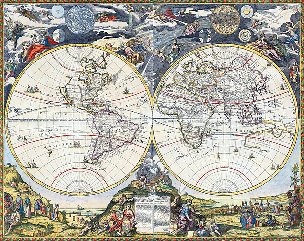
Map of the world by Paolo Petrini, 1700.
This double-hemisphere world map by Neapolitan mapmaker Paolo Petrini represents the high point of... more
Care Instructions
Machine wash cold and tumble dry with low heat.
Ships Within
1 - 2 business days

Photograph

Canvas Print

Framed Print

Art Print

Poster

Metal Print

Acrylic Print

Wood Print

Greeting Card

iPhone Case

Throw Pillow

Duvet Cover

Shower Curtain

Tote Bag

Round Beach Towel

Zip Pouch

Beach Towel

Weekender Tote Bag

Portable Battery Charger

Bath Towel

Apparel

Coffee Mug

Yoga Mat

Spiral Notebook

Fleece Blanket

Tapestry

Jigsaw Puzzle

Sticker

Ornament
Map of the world by Paolo Petrini, 1700.
This double-hemisphere world map by Neapolitan mapmaker Paolo Petrini represents the high point of geographic printing in Naples at the end of the 17th Century.
The hemispheres are surrounded by finely engraved allegorical images. This map is an original composition, although his cartographic sources can be traced to important French and Italian sources. Eastern North America is reasonably well-defined, with all five of the Great Lakes, the Mississippi River, alifornia is shown to be a large island, while in the Pacific Northwest, the coast curves inwards to include the mythical Strait of Anian. South America takes on an exaggerated, widened form, although the Andes and major rivers are depicted with a broad degree of accuracy.
Much of the rest of the world and the nomenclature, were taken from the 1694 wall map of the world by the French Geographer Royale, Nicolas de Fer. Europe is naturally well-defined and Africa assumes...
Hi there, Born in '72 and shooting pictures since '83, I particularly enjoy creating wide panoramic compositions, HDRs, HDR Panoramas... But not just... Here you will find landscapes and cityscapes, ancient ruins and modern buildings, moons and seas, planes and boats, guns and flowers, animals and machines, forests and deserts, vanguard and prehistory, digital and film, color and black & white, graves and newborns, temples, trenches, palaces, castles, tanks, churches, bunkers... However, they have some things in common: they are meaningful images, I believe them all to be beautiful, and they are for the most part unique. Come in and judge for yourself. W. W. WE CAN CUSTOMIZE ANY PICTURE TO YOUR PERSONAL LIKING AND MAKE IT...
$60.00


